Black Mountain Vortex
-
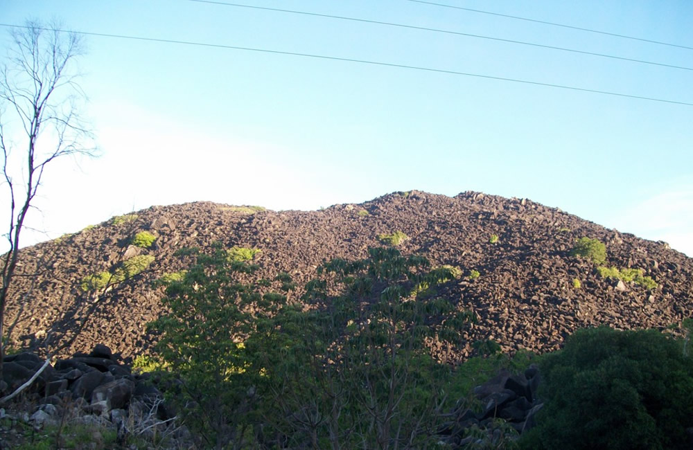
Black Mountain (Kalkajaka) National Park is a protected area in the Queensland, (Australia), 25 km south west of Cooktown. The main feature of the park is the mass of granite boulders, some the size of houses.
The absence of soil between the boulders and rocks create a maze of gaps and passages, which can be used to penetrate inside the mountain. These rocks can become extremely hot. The area has a bad reputation as numerous people and those searching for the missing have disappeared without trace.
The national park's distinctive hard granite boulders and range originally formed out of magma that first slowly solidified under the Earth's crust about 250 million years ago. The softer land surfaces above the solidified magma eroded away over time, leaving the magma's fractured top to be exposed as a mountain of grey granite boulders blackened by a film of microscopic blue-green algae growing on the exposed surfaces. Colder rains falling on the dark, heated granite boulders causes the boulders to progressively fracture, break, and slowly disintegrate, sometimes explosively.
-
The National Park's "Black Mountains" are a heavily significant feature of the Kuku Nyungkal people's cultural landscape known locally to Aboriginal Australians as Kalkajaka (trans: "place of spear").
There are at least four sites of religious or mythological significance on the mountain. These are the Kambi, a large rock with a cave where flying-foxes are found; Julbanu, a big grey kangaroo-shaped rock looking toward Cooktown; Birmba, a stone facing toward Helenvale where sulphur-crested cockatoos are seen; and a taboo place called Yirrmbal near the foot of the range.
Stories abound of people, horses and whole mobs of cattle disappearing into the labyrinth of rocks, never to be seen again It is believed that those who vanished most probably fell into one of the chasms under the rocks or after entering one of these places became lost.
The discussion of mysterious features of the Black Mountain featured in an episode of the Ancient Aliens television series on the History Channel. The series claimed that the hills of the Kalkajaka could have been formed by ancient astronauts who piled the huge boulders to cover up a massive mining operation, or, alternatively, that the boulders were debris formed as a result of the mining operation.
Source: Wikipedia
-
POSTS
26 March 2025
Elle, QLD. Australia: Vortex Hunting - Heya, Just writing to suggest further possible vortex locations near me. I am located and born in Cairns. I was raised with a stories of the Babinda Boulder spirits dragging people into the literal water vortexes that slip under enormous boulders. Many people have lost their lives there. Before the pandemic they were already trying to shut access to this local hot spot down due to local inability to leave no trace. Further North we have our own black mountain which you likely already know about due to ancient aliens. Now the reason I contacted someone was in an attempt to get my hands on a map of ley lines that correlates with the inclusion of these 2 locations as well as Ross and Locke which is a rec spot locals hang out, located in the Murray river near Gordonvale. Now, down the middle of the river is a train line. Quite astonishingly this is a cane farmers land so not much can be done there without the surrounding property owners keeping a peeled eye out for suspicious activity. I am now 30 but when I was 18 a couple friends and I took a night trip down there; now connecting one part to the middle part with the incline that backs onto the rear of the farm there is a car bridge. Running adjacent to that about 3 meters in front of it is an old abandoned train bridge with the sleepers and stone slabs still there… after consulting AI I’ve concluded that; if you jump in the water at night with your high beams pointing up the river (yes, risking a croc bite), get in thigh deep and break the surface tension of the water with your finger tips ever so gently for about 2 minutes on a clear night you can create ball lightning on cue using the old train bridge (be sure to look there) and the mineral deposits on either side of it that get washed down from the mineral rich tablelands every time it rains. I had to be about 20m on the opposing bank. Your hair will also do the frizz thing. Up top there is also the Innot Hot Springs… visitors know this region as the waterfall trail. There is an incredibly rich history in this region. Do you have any maps that align with what you already have as well as these? Here they have song lines but deciphered they are like a rhyme about landmarks along a journey they would travel. This mountain range runs down to the Gosford glyphs. If you were to land in Australia on this part of the coast you would head inland along the ridges like a cassowary. Whoever this ancient civilisation was that seemed to have already discovered the whole world once before seemed to be trying to find the most reliable water and fertile land sources in high elevation as well as gold. - Shantelle
-
Resources
Image by Bruceanthro at en.wikipedia [CC BY-SA 3.0 (http://creativecommons.org/licenses/by-sa/3.0) or GFDL (http://www.gnu.org/copyleft/fdl.html)], via Wikimedia Commons
-
Note: There is currently no scientific method to prove that vortexes exist. Just because a location is on the vortex map, does not prove there is a vortex there. What it means, is that someone suggested the location and provided evidence or a personal account, and/or we found corroborating evidence from other sources. We do this so other visitors to the site can send us their opinion on the validity of the vortex claim, to build a consensus.
Have you visited this location? If so, contact us and let us know if you think this place is a vortex or not. We will post your comments here.